
.png)
Automobile History in Ute Pass and Highway 24 - Part 3
- Steve Plutt

- Sep 2, 2025
- 10 min read
By Steve Plutt © 2023
Part 3: Four Lanes and the Woodland Park Bypass
By the end of 1937, the once oxen trail up Ute Pass and the wagon road from Cascade to Divide was now a modern, wide and oiled highway. But only ten years later, in July of 1948 after the Midland Terminal Railroad was abandoned, talk of installing another lane in Ute Pass began. Remember that this idea was first proposed in 1926. Property owners all along Ute Pass urged the State Highway Department to make use of the available Midland right of way. Frank J. Cusack who was then president of the Cascade Town Company wrote a letter to the state highway engineer telling of widespread support from residents for this idea. The 1948 efforts for this expansion never came to be, but the concept stayed alive.
On September 17, 1963 plans for a four-lane highway between Manitou and Cascade began once again. A public meeting was held at Memorial Hall in Manitou with discussions and plans made between the State Highway Department and all interested residents. Frank Cusack urged all Ute Pass residents to attend the meeting and learn about the planned development of the Highway 24 west.

Cusack is quoted as saying that “I cannot exaggerate the importance of Tuesday’s meeting….particularly for those in the Woodland Park, Ute Pass and Manitou Springs area.” The plan at this time was to four-lane the highway from 8th Steet in Colorado Springs up to Cascade.
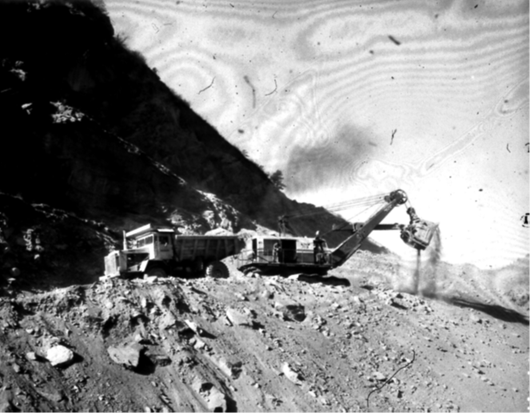
With the above headlines, the Colorado Highway Department revealed that construction of a new four lane divided highway would begin one year from the announcement, in September of 1964 with a completion date in the spring of 1965, although it actually wasn’t opened until the end of July, 1965. This four-lane section now eliminated the painful ordeal of westbound traffic being stuck behind big trucks and other slow-moving vehicles through the narrowest parts of the canon.
This project was three parts; the Midland Expressway being the first phase, which was already under construction in 1963, and Ute Pass to Cascade being the second phase. The third phase was the section in or around Manitou, which hadn’t yet been decided at the time of the 1963 headline, shown above.
That decision did come quickly though.
In the spring of 1964 the Manitou Bypass route was announced. The bypass would be a total of 2.2 miles of four lane from 31st Street to Rainbow Falls and it would bypass Manitou all together as shown by the front page below map.

The cost of this project was $3,000,000 with an additional $2,000,000 expended on the purchase of expensive right of way, particularly though the area we all know as Little Switzerland.
The route would pass south of the Cliff Dwellings over the top of Cliff Road, then by bridge 96 feet above Cañon Avenue and lastly by bridge over Fountain Creek at Rainbow Falls. This route would have quite the terrain challenges with massive rock cuts and very deep canyons to fill or cross. The completed project replaced Colorado Avenue as the main route. A nostalgic footnote on this project, I can vividly remember each time I traveled to Colorado Springs, which at that time took you right through downtown Manitou, looking up on the hills above town wondering what all those big bull dozers were doing way up there. Remember, there was no social media at that time to keep us all informed on local happenings.

Despite all of the Manitou Bypass planning and even as construction was now in progress, the U.S. Army Corps of Engineers introduced a proposed 290 foot tall, 19 million dollar dam a mile and a half above Manitou in Ute Pass. That announcement was front page news in July of 1967. It would force the relocation of Highway 24 and a revamping of the new Manitou Bypass. It was reported that the dam would back up 22,000 acre feet of water. The spillway would measure 300 feet wide.

By mid-August of ’67, amid tremendous citizen outroar, the plan was abandoned by the Corps and none of this scheme ever materialized. Among Manitou Springs and Ute Pass area residents, there were zero mourners of this canceled project.
At last! After years of bickering, lawsuits, weather, landslides and court battles, the Manitou Bypass had a formal ribbon cutting ceremony and officially opened on October 23, 1969. Manitou Springs Mayor Ralph Sumner led the ceremony that took place on the Williams Canyon Bridge that carries traffic over Cañon Avenue.

The opening of this bypass was considered a “key factor in planned growth of the Upper Ute Pass region.”
The new bypass also triggered the Board of County Commissioners in both El Paso and Teller County to send a request to the Colorado State Highway Commission. Both BOCCs asked the state to continue four lanes of traffic to Woodland Park as soon as possible.
The opening of the Manitou Bypass completed the Highway 24 project and four lanes from 31st Street up to Cascade. The stretch from 31st Street east to 8th Street, known as the Midland Expressway, had recently been completed and the Ute Pass/Manitou Bypass was now linked to it. We no longer had to travel through Manitou Springs and along Colorado Avenue on our way to destinations in Colorado Springs. As a footnote, keep in mind that back then, downtown Colorado Springs was everyone’s main destination. There were no Academy Boulevard malls, no Powers Boulevard shopping centers; Knob Hill was about as far east of downtown as one traveled.
With the Manitou Bypass in place and now open, it came to light that CDOT wanted Highway 24 to bypass Woodland Park. The proposal was to build a new highway from Crystola, up Crystola Canyon and connecting 24 at Edlowe. This caused much excitement in the town and Woodland Park business owners and their allies immediately opposed the project.
The new Manitou Bypass and four lanes to Cascade also led to the predicted growth for Ute Pass and Woodland Park and was becoming a reality. Folks that had lived in and around Colorado Springs were now moving to what used to be at the time, a quite, serene place to live in a scenic, rural environment that had a strong western culture, such as the Ute Pass Region was back then.
Four Lanes to Green Mountain Falls. The next phase of the four-lane extension would continue from Cascade to the western exit to Green Mountain Falls. This section was split into two projects, one was the 2.2 miles from Cascade west and the other was the following 2 miles that took the four lanes to the Green Mountain exit. Construction on the first section started on July 31, 1972 while the second part started on August 10, 1972.
When completed, I recall that many drivers as they came down the west side of Motel X Hill could see ahead for that last one third of a mile of four lane. They would accelerate as much as possible to get around slow movers before it went back to two lanes. So that left lane was quite the high-speed raceway as the highway went back to two lanes.

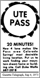
By 1973, and to the grumblings of some, portions of upper Ute Pass were being built up both commercially and residentially. The author of this 1973 headline would be dumbfounded at all the homes visible today along the slopes above Chipita Park and Green Mountain Falls. That same author would be beyond amazed at the agonizing bottleneck congestion of Woodland Park and all of that town’s strip malls of fast food chains and big box stores.
Phase 3. On February 19, 1974 the state highway department held a public meeting to answer questions about the next phase of the highway 24 extension. Phase Three would expand 3.3 miles of road from Green Mountain Falls to Paradise Ranch, just south of Woodland Park. More than 300 people showed up to listen and ask questions, although the bigger concern that evening was what future plans the State Highway Department had in mind for Woodland Park.

The state said they had some varying ideas to suggest for Woodland. One was to widen the highway through town with a concrete median dividing east and west bound traffic. The current width at that time was 80 to 100 wide. The proposal would increase that to 175 and even 200 feet wide.
The second option would be as the first but with a frontage road on the north side of the new road along Midland Avenue. The frontage road would be separated from the main highway by a raised curb. The next thought the state had was to bypass Woodland Park altogether.
These possible suggested routes kicked up a long, divided and many times heated debate in Woodland Park which essentially was a division that pitted business owners against residents. The Woodland Park Chamber of Commerce favored a four-lane highway with a two-lane frontage road straight through the middle of Woodland Park while the citizens wanted a complete bypass around the town.
So, the Town Council voted unanimously to put the route on the April 2 election ballot as an “advisory question” and let the voters decide. The results would have no legal impact but would at least reveal the popular opinion. A Ute Pass Courier editorial comment felt that no matter which route was chosen at the polls, that the voting majority will only “breed more argument in an already bitter and distasteful controversy.”
So, there were two choices on the ballot: keep the present location or bypass the central business district. Arguing for the bypass, local resident F.C. Ware said in his letter to the editor of March 28 that according to U.S. Dept of Transportation studies, “when traffic was not in town, the town benefits by lighter traffic, greater safety, more convenient shopping with resulting better business climate.”
Arguing against the bypass was Woodland Park Chamber of Commerce President Joan Stull who presented a petition from Woodland Park businesses supporting the route through the middle of town.
By more than three to one, the voters overwhelmingly advocated in favor of a bypass, although voter turnout was very low.

However, after everything was said and done, CDOT dropped all plans to bypass Woodland Park because the business community and the Chamber of Commerce objected to the bypass. The issue was dead.
Many Woodland Park residents felt that this was a vindictive decision that had roots back to 1965 when CDOT wanted to bypass the town but the business community of Woodland Park shut that plan down too.
The bypass topic remained quiet for several years, even though it was still a concern and on a lot of minds.
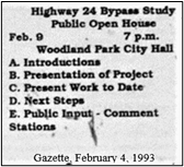
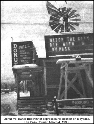
It wasn’t until 1993 that the issue came up again. There were a total of 16 routing proposals for a Woodland Park bypass that were later narrowed down to six and then three. But these three routes featured the same old divisions among businesses and residents. In fact there were even two different resident sides this time as different neighborhoods didn’t want it near them.

At the February 9, 1993 public open house held at City Hall, over 300 residents and business owners showed up. At issue was Option A, to route traffic through downtown with some improvements, Option B, create a new business loop through downtown or Option C, to bypass the city completely.
Corridor A would equal “as is” and would have been the least intense. State and local governments would improve the present roadway and perhaps install overhead walkways or underground tunnels for pedestrian crossings.
Corridor B would be more of a semi bypass and traffic would flow along Columbine Avenue within sight of downtown. Proponents of this plan were the business community.
Corridor C would be a true bypass around the business sector, beginning somewhere near present-day Aspen Gardens Way and exiting near South Forty Road. Advocates of this route were the residents of Woodland Park. Each Corridor had several differing alternative access and egress points and Corridor C had residents divided amongst themselves. Mayor Clarke Becker said “This is an emotional issue before us.” It was thought to put the issue on the ballot and leave it up to the voters to decide, but Becker was not in favor of that. Remember, such a vote was taken in 1974 and the electorate favored, by 3-1, a total bypass.

The Ute Pass Courier reported that it may take as long as a year to determine the best route. State officials said it would be at least seven years before a bypass of any kind could be built, further noting that they didn’t have an obligation to build a bypass at all.
Which corridor route was hotly debated among interested parties in Woodland Park. Business owners were accused of scare tactics to persuade City Council to their favored route.
Former Council member Mike Clausen urged Council to look at the issue in the long term. He said “a bypass would make downtown redevelopment possible and give the residents back the old area of the city in which to live and shop.”
This February 9 meeting was just the beginning of more scheduled public input meetings with March 6, 1993 the next planned assembly. However, the City of Woodland Park’s “Study Committee” that was charged with studying the issue, abruptly halted the process. They announced that the March 6 meeting had been canceled. The scheduled March 11 meeting was rescheduled to March 23 and that no public comment would be allowed.

“You’ll be lucky if it’s built in the year 2000,” said CDOT’s Region 2 Deputy Director. The bypass issue ended up dying again with the Courier reporting that CDOT said that funds for a Woodland Park bypass would not be available until at least 2000.
So, the big bypass for Woodland Park was again dead in the water. However, the City formed a 150-member citizens committee to study the choices so Woodland would have a documented plan when and if the State ever decided to build a bypass. What route did the committee chose? Well, spur of the moment conceived “Corridor D” of course! That plan was a last-moment option urged by residents upset with the other three routes. That route offered few details but it would cover rough, uneven ground and required a pair of bridges as high as 100 feet. While City officials were pleased with the group’s decision, businessman George Drake complained that “You can’t make a decision of this magnitude with just 45 minutes of information.”
With the bypass issue now dead yet again, the Ute Pass Courier ran a story on July 15, 1993 telling us that highway 24 needs to improve for safety and to create an “inviting downtown”. They continued saying that “a bypass around the city will be necessary to handle the volume of traffic anticipated here in the next 10 to 15 years.”
Download a PDF of this series with footnotes and bibliography


Comments